
Münchenberg topographic map
Interactive map
Click on the map to display elevation.
About this map
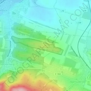
Name: Münchenberg topographic map, elevation, terrain.
Average elevation: 636 ft
Minimum elevation: 453 ft
Maximum elevation: 1,148 ft
Other topographic maps
Click on a map to view its topography, its elevation and its terrain.
Treseburg
Deutschland > Sachsen-Anhalt > Landkreis Harz > Thale
Treseburg, Thale, Landkreis Harz, Sachsen-Anhalt, Deutschland
Average elevation: 1,325 ft
Rappbodetalsperre
Deutschland > Sachsen-Anhalt > Landkreis Harz > Thale
Rappbodetalsperre, Rübeland, Thale, Oberharz am Brocken, Landkreis Harz, Sachsen-Anhalt, 38889, Deutschland
Average elevation: 1,411 ft
Friedrichsbrunn
Deutschland > Sachsen-Anhalt > Landkreis Harz > Thale
Friedrichsbrunn, Thale, Landkreis Harz, Sachsen-Anhalt, Deutschland
Average elevation: 1,535 ft
Allrode
Deutschland > Sachsen-Anhalt > Landkreis Harz > Thale
Allrode, Thale, Landkreis Harz, Sachsen-Anhalt, Deutschland
Average elevation: 1,516 ft
Westerhausen
Deutschland > Sachsen-Anhalt > Landkreis Harz > Thale
Westerhausen, Thale, Landkreis Harz, Sachsen-Anhalt, Deutschland
Average elevation: 522 ft
Altenbrak
Deutschland > Sachsen-Anhalt > Landkreis Harz > Thale
Altenbrak, Thale, Landkreis Harz, Sachsen-Anhalt, Deutschland
Average elevation: 1,388 ft