
Make a donation
Gear up for your next adventure:
As an Amazon Associate, this site earns from qualifying purchases at no extra cost to you.
Rappbodetalsperre topographic map
Click on the map to display elevation.
Make a donation
Gear up for your next adventure:
As an Amazon Associate, this site earns from qualifying purchases at no extra cost to you.
Rappbodetalsperre
Die von 1952 bis 1959 erbaute und nahezu vollständig gerade Gewichtsstaumauer, die durch ihr Eigengewicht die Rappbode aufstaut, ist etwa 415 m lang, an ihrer Krone 12,50 m und an der Basis rund 78 m breit. Über der Talsohle ist sie zirka 90 m und über der Gründungssohle 106,0 m hoch. Ihre Gründungshöhe liegt auf etwa 321 m ü. NHN und die Bauwerkskrone auf rund 427 m ü. NHN. Das Bauwerksvolumen enthält zirka 860.000 m³ Beton. Die Mauer besteht aus 30 Segmenten (Feldern) mit maximal 16 m Segmentbreite. Die Hochwasserentlastung besteht aus einem freien Mauerkronenüberlauf mit einer Gesamtbreite von 64 m, der durch acht Zwischenpfeiler in neun Felder aufgeteilt ist und bei einer Überströmhöhe von 1,10 m 120 m³ Wasser pro Sekunde ableiten kann.
Make a donation
Gear up for your next adventure:
As an Amazon Associate, this site earns from qualifying purchases at no extra cost to you.
About this map
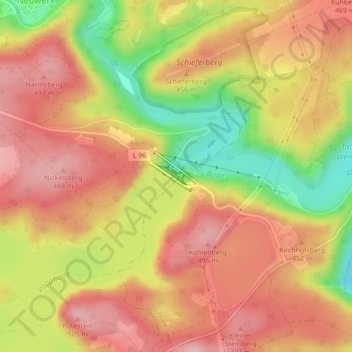
Name: Rappbodetalsperre topographic map, elevation, terrain.
Average elevation: 1,411 ft
Minimum elevation: 1,066 ft
Maximum elevation: 1,631 ft
Make a donation
Gear up for your next adventure:
As an Amazon Associate, this site earns from qualifying purchases at no extra cost to you.