
Thank you for supporting this site ❤️
Make a donation
Make a donation
Gear up for your next adventure:
As an Amazon Associate, this site earns from qualifying purchases at no extra cost to you.
Morandini topographic map
Click on the map to display elevation.
Thank you for supporting this site ❤️
Make a donation
Make a donation
Gear up for your next adventure:
As an Amazon Associate, this site earns from qualifying purchases at no extra cost to you.
About this map
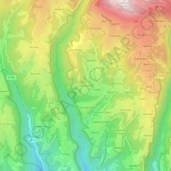
Name: Morandini topographic map, elevation, terrain.
Location: Morandini, Erbezzo, Verona, Veneto, 37020, Italia (45.61646 10.96067 45.65646 11.00067)
Average elevation: 3,048 ft
Minimum elevation: 1,873 ft
Maximum elevation: 4,501 ft
Thank you for supporting this site ❤️
Make a donation
Make a donation
Gear up for your next adventure:
As an Amazon Associate, this site earns from qualifying purchases at no extra cost to you.