
Make a donation
Gear up for your next adventure:
As an Amazon Associate, this site earns from qualifying purchases at no extra cost to you.
Rustenburg topographic map
Click on the map to display elevation.
Make a donation
Gear up for your next adventure:
As an Amazon Associate, this site earns from qualifying purchases at no extra cost to you.
Rustenburg
Rustenburg is at the foot of the Magaliesberg Range in South Africa, positioned on the Highveld Plateau, at an elevation of 1,217 meters (3,993 ft) above sea level with a minimum of 1,028 m and a maximum of 1,756 m. The terrain includes a mix of urban, mining and natural areas such as the Magaliesberg Biosphere Reserve.
Make a donation
Gear up for your next adventure:
As an Amazon Associate, this site earns from qualifying purchases at no extra cost to you.
About this map
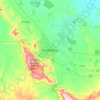
Name: Rustenburg topographic map, elevation, terrain.
Average elevation: 3,993 ft
Minimum elevation: 3,373 ft
Maximum elevation: 5,761 ft
Make a donation
Gear up for your next adventure:
As an Amazon Associate, this site earns from qualifying purchases at no extra cost to you.
Other topographic maps
Click on a map to view its topography, its elevation and its terrain.
Hartbeespoort Dam
South Africa > North West > Bojanala Platinum District Municipality > Madibeng Local Municipality > Kosmos
Average elevation: 4,114 ft
Pilanesberg National Park
South Africa > North West > Bojanala Platinum District Municipality
Average elevation: 3,891 ft
Madibeng Local Municipality
South Africa > North West > Bojanala Platinum District Municipality
Average elevation: 3,763 ft
Pienaars River
South Africa > North West > Bojanala Platinum District Municipality > Madibeng Local Municipality
Average elevation: 3,386 ft
Make a donation
Gear up for your next adventure:
As an Amazon Associate, this site earns from qualifying purchases at no extra cost to you.
Moretele Local Municipality
South Africa > North West > Bojanala Platinum District Municipality
Average elevation: 3,468 ft
Vaalkop Dam
South Africa > North West > Bojanala Platinum District Municipality > Rustenburg Local Municipality
Average elevation: 3,238 ft
Rooikoppies Dam
South Africa > North West > Bojanala Platinum District Municipality > Madibeng Local Municipality
Average elevation: 3,435 ft
Hex River
South Africa > North West > Bojanala Platinum District Municipality > Rustenburg
Average elevation: 3,967 ft
Make a donation
Gear up for your next adventure:
As an Amazon Associate, this site earns from qualifying purchases at no extra cost to you.
Moses Kotane Local Municipality
South Africa > North West > Bojanala Platinum District Municipality
Average elevation: 3,556 ft
Rustenburg Local Municipality
South Africa > North West > Bojanala Platinum District Municipality
Average elevation: 4,222 ft
Ukutula Lodge & Lion Park
South Africa > North West > Bojanala Platinum District Municipality > Madibeng Local Municipality
Average elevation: 3,560 ft
Rustenburg Local Municipality
South Africa > North West > Bojanala Platinum District Municipality
Average elevation: 4,222 ft
Make a donation
Gear up for your next adventure:
As an Amazon Associate, this site earns from qualifying purchases at no extra cost to you.
Kgaswane Mountain Nature Reserve
South Africa > North West > Bojanala Platinum District Municipality > Rustenburg Local Municipality
Average elevation: 4,288 ft
Moretele Local Municipality
South Africa > North West > Bojanala Platinum District Municipality
Average elevation: 3,468 ft
Moses Kotane Local Municipality
South Africa > North West > Bojanala Platinum District Municipality
Average elevation: 3,556 ft
Madibeng Local Municipality
South Africa > North West > Bojanala Platinum District Municipality
Average elevation: 3,763 ft
Make a donation
Gear up for your next adventure:
As an Amazon Associate, this site earns from qualifying purchases at no extra cost to you.
Moretele Local Municipality
South Africa > North West > Bojanala Platinum District Municipality
Average elevation: 3,468 ft
Madibeng Local Municipality
South Africa > North West > Bojanala Platinum District Municipality
Average elevation: 3,763 ft
Kgetleng River Local Municipality
South Africa > North West > Bojanala Platinum District Municipality
Average elevation: 4,485 ft
Rooikoppies Dam
South Africa > North West > Bojanala Platinum District Municipality > Madibeng Local Municipality
Average elevation: 3,435 ft
Make a donation
Gear up for your next adventure:
As an Amazon Associate, this site earns from qualifying purchases at no extra cost to you.
Kgetlengrivier Ward 2
South Africa > North West > Bojanala Platinum District Municipality > Kgetleng River Local Municipality
Average elevation: 4,193 ft
Valley of Waves
South Africa > North West > Bojanala Platinum District Municipality > Moses Kotane Local Municipality > Sun City
Average elevation: 3,855 ft
Madibeng Ward 14
South Africa > North West > Bojanala Platinum District Municipality > Madibeng Local Municipality
Average elevation: 3,501 ft
Moses Kotane Local Municipality
South Africa > North West > Bojanala Platinum District Municipality
Average elevation: 3,556 ft
Make a donation
Gear up for your next adventure:
As an Amazon Associate, this site earns from qualifying purchases at no extra cost to you.
Moses Kotane Local Municipality
South Africa > North West > Bojanala Platinum District Municipality
Average elevation: 3,556 ft
Elands
South Africa > North West > Bojanala Platinum District Municipality
Average elevation: 3,793 ft