
Make a donation
Gear up for your next adventure:
As an Amazon Associate, this site earns from qualifying purchases at no extra cost to you.
Madibeng Local Municipality topographic map
Click on the map to display elevation.
Make a donation
Gear up for your next adventure:
As an Amazon Associate, this site earns from qualifying purchases at no extra cost to you.
About this map
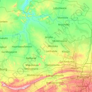
Name: Madibeng Local Municipality topographic map, elevation, terrain.
Average elevation: 3,763 ft
Minimum elevation: 3,061 ft
Maximum elevation: 6,050 ft
Make a donation
Gear up for your next adventure:
As an Amazon Associate, this site earns from qualifying purchases at no extra cost to you.
Other topographic maps
Click on a map to view its topography, its elevation and its terrain.
Klipgat
South Africa > North West > Bojanala Platinum District Municipality > Madibeng Local Municipality
Average elevation: 3,802 ft
Elandsrand
South Africa > North West > Bojanala Platinum District Municipality > Madibeng Local Municipality
Average elevation: 3,743 ft
Brits
South Africa > North West > Bojanala Platinum District Municipality > Madibeng Local Municipality
Average elevation: 3,675 ft
Letlhabile
South Africa > North West > Bojanala Platinum District Municipality > Moses Kotane Local Municipality
Average elevation: 3,727 ft
Make a donation
Gear up for your next adventure:
As an Amazon Associate, this site earns from qualifying purchases at no extra cost to you.
Rustenburg
South Africa > North West > Bojanala Platinum District Municipality
Rustenburg has a humid subtropical climate (Köppen Cwa), with a relatively high degree of diurnal temperature variation due to the high elevation. It has very warm summers (from December to February) and mild winters (from June to August). Due to the altitude, summers are not quite as hot as one might expect.…
Average elevation: 3,993 ft
Ga-Luka
South Africa > North West > Bojanala Platinum District Municipality > Rustenburg Local Municipality
Average elevation: 3,645 ft
Mogwase
South Africa > North West > Bojanala Platinum District Municipality > Moses Kotane Local Municipality
Average elevation: 3,593 ft
Moretele
South Africa > North West > Bojanala Platinum District Municipality > Moretele Local Municipality
Average elevation: 3,346 ft
Make a donation
Gear up for your next adventure:
As an Amazon Associate, this site earns from qualifying purchases at no extra cost to you.
Rustenburg
South Africa > North West > Bojanala Platinum District Municipality
Rustenburg has a humid subtropical climate (Köppen Cwa), with a relatively high degree of diurnal temperature variation due to the high elevation. It has very warm summers (from December to February) and mild winters (from June to August). Due to the altitude, summers are not quite as hot as one might expect.…
Average elevation: 3,993 ft
Klipgat
South Africa > North West > Bojanala Platinum District Municipality > Madibeng Local Municipality
Average elevation: 3,802 ft
Hartbeespoort Dam
South Africa > North West > Bojanala Platinum District Municipality > Madibeng Local Municipality > Kosmos
Average elevation: 4,114 ft
Swartruggens
South Africa > North West > Bojanala Platinum District Municipality > Kgetleng River Local Municipality
Average elevation: 4,288 ft
Make a donation
Gear up for your next adventure:
As an Amazon Associate, this site earns from qualifying purchases at no extra cost to you.
Hartebeespoort Dam
South Africa > North West > Bojanala Platinum District Municipality > Madibeng Local Municipality > Kosmos
Average elevation: 3,865 ft
Pienaars River
South Africa > North West > Bojanala Platinum District Municipality > Madibeng Local Municipality
Average elevation: 3,386 ft
Moruleng
South Africa > North West > Bojanala Platinum District Municipality > Moses Kotane Local Municipality
Average elevation: 3,688 ft
Broederstroom
South Africa > North West > Bojanala Platinum District Municipality > Madibeng Local Municipality
Average elevation: 4,147 ft
Make a donation
Gear up for your next adventure:
As an Amazon Associate, this site earns from qualifying purchases at no extra cost to you.
Vaalkop Dam
South Africa > North West > Bojanala Platinum District Municipality > Rustenburg Local Municipality
Average elevation: 3,238 ft
Damonsville
South Africa > North West > Bojanala Platinum District Municipality > Madibeng Local Municipality
Average elevation: 3,852 ft
Rooikoppies Dam
South Africa > North West > Bojanala Platinum District Municipality > Madibeng Local Municipality
Average elevation: 3,435 ft
Madikwe
South Africa > North West > Bojanala Platinum District Municipality > Moses Kotane Local Municipality
Average elevation: 3,445 ft
Make a donation
Gear up for your next adventure:
As an Amazon Associate, this site earns from qualifying purchases at no extra cost to you.
Jericho
South Africa > North West > Bojanala Platinum District Municipality > Madibeng Local Municipality
Average elevation: 3,432 ft
Hex River
South Africa > North West > Bojanala Platinum District Municipality > Rustenburg
Average elevation: 3,967 ft
Koffiekraal
South Africa > North West > Bojanala Platinum District Municipality > Moses Kotane Local Municipality
Average elevation: 3,327 ft
Rasimone
South Africa > North West > Bojanala Platinum District Municipality > Rustenburg Local Municipality
Average elevation: 3,645 ft
Make a donation
Gear up for your next adventure:
As an Amazon Associate, this site earns from qualifying purchases at no extra cost to you.
Ukutula Lodge & Lion Park
South Africa > North West > Bojanala Platinum District Municipality > Madibeng Local Municipality
Average elevation: 3,560 ft
Phokeng
South Africa > North West > Bojanala Platinum District Municipality > Rustenburg Local Municipality
Average elevation: 3,944 ft
Mmakau
South Africa > North West > Bojanala Platinum District Municipality > Madibeng Local Municipality
Average elevation: 4,088 ft
Kagiso
South Africa > North West > Bojanala Platinum District Municipality > Moses Kotane Local Municipality
Average elevation: 3,727 ft
Make a donation
Gear up for your next adventure:
As an Amazon Associate, this site earns from qualifying purchases at no extra cost to you.
Kosmos
South Africa > North West > Bojanala Platinum District Municipality > Madibeng Local Municipality
Average elevation: 3,983 ft
Chaneng
South Africa > North West > Bojanala Platinum District Municipality > Rustenburg Local Municipality
Average elevation: 3,474 ft
Mapetla
South Africa > North West > Bojanala Platinum District Municipality > Madibeng Local Municipality
Average elevation: 4,039 ft
Moretele
South Africa > North West > Bojanala Platinum District Municipality > Moretele Local Municipality
Average elevation: 3,346 ft
Make a donation
Gear up for your next adventure:
As an Amazon Associate, this site earns from qualifying purchases at no extra cost to you.
Ledig
South Africa > North West > Bojanala Platinum District Municipality > Moses Kotane Local Municipality
Average elevation: 3,655 ft
Koster
South Africa > North West > Bojanala Platinum District Municipality > Kgetleng River Local Municipality
Average elevation: 5,098 ft
Broederstroom
South Africa > North West > Bojanala Platinum District Municipality > Madibeng Local Municipality
Average elevation: 4,147 ft
Tshukudu Bush Lodge
South Africa > North West > Bojanala Platinum District Municipality > Moses Kotane Local Municipality
Average elevation: 4,232 ft
Make a donation
Gear up for your next adventure:
As an Amazon Associate, this site earns from qualifying purchases at no extra cost to you.
Rooikoppies Dam
South Africa > North West > Bojanala Platinum District Municipality > Madibeng Local Municipality
Average elevation: 3,435 ft
Modderspruit
South Africa > North West > Bojanala Platinum District Municipality > Madibeng Local Municipality
Average elevation: 3,986 ft
Koster
South Africa > North West > Bojanala Platinum District Municipality > Kgetleng River Local Municipality
Average elevation: 5,098 ft
Swartruggens
South Africa > North West > Bojanala Platinum District Municipality > Kgetleng River Local Municipality
Average elevation: 4,288 ft
Make a donation
Gear up for your next adventure:
As an Amazon Associate, this site earns from qualifying purchases at no extra cost to you.
Kosmos
South Africa > North West > Bojanala Platinum District Municipality > Madibeng Local Municipality
Average elevation: 3,983 ft
Phokeng
South Africa > North West > Bojanala Platinum District Municipality > Rustenburg Local Municipality
Average elevation: 3,944 ft
Valley of Waves
South Africa > North West > Bojanala Platinum District Municipality > Moses Kotane Local Municipality > Sun City
Average elevation: 3,855 ft
Mooinooi
South Africa > North West > Bojanala Platinum District Municipality > Madibeng Local Municipality
Average elevation: 3,973 ft
Make a donation
Gear up for your next adventure:
As an Amazon Associate, this site earns from qualifying purchases at no extra cost to you.
Mogwase
South Africa > North West > Bojanala Platinum District Municipality > Moses Kotane Local Municipality
Average elevation: 3,593 ft
Modderspruit
South Africa > North West > Bojanala Platinum District Municipality > Madibeng Local Municipality
Average elevation: 3,986 ft
Bapong
South Africa > North West > Bojanala Platinum District Municipality > Madibeng Local Municipality
Average elevation: 3,924 ft
Brits
South Africa > North West > Bojanala Platinum District Municipality > Madibeng Local Municipality
Average elevation: 3,675 ft
Make a donation
Gear up for your next adventure:
As an Amazon Associate, this site earns from qualifying purchases at no extra cost to you.