
Make a donation
Gear up for your next adventure:
As an Amazon Associate, this site earns from qualifying purchases at no extra cost to you.
Mersi topographic map
Click on the map to display elevation.
Make a donation
Gear up for your next adventure:
As an Amazon Associate, this site earns from qualifying purchases at no extra cost to you.
About this map
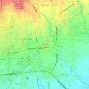
Name: Mersi topographic map, elevation, terrain.
Location: Mersi, Banyumas, Central Java, Java, 53112, Indonesia (-7.44564 109.24492 -7.40564 109.28492)
Average elevation: 249 ft
Minimum elevation: 157 ft
Maximum elevation: 374 ft
Make a donation
Gear up for your next adventure:
As an Amazon Associate, this site earns from qualifying purchases at no extra cost to you.
Other topographic maps
Click on a map to view its topography, its elevation and its terrain.
Desa Banjarsari Kidul Kecamatan Sokaraja
Indonesia > Central Java > Banyumas
Average elevation: 105 ft
Desa Banjar Anyar Kidul Kecamatan Sokaraja
Indonesia > Central Java > Banyumas
Average elevation: 141 ft
Lokawisata Baturraden
Indonesia > Central Java > Banyumas > Purwokerto Lor
Average elevation: 2,303 ft
Make a donation
Gear up for your next adventure:
As an Amazon Associate, this site earns from qualifying purchases at no extra cost to you.