Geolocate

Dhotri topographic map

Interactive map

Click on the map to display elevation.

About this map

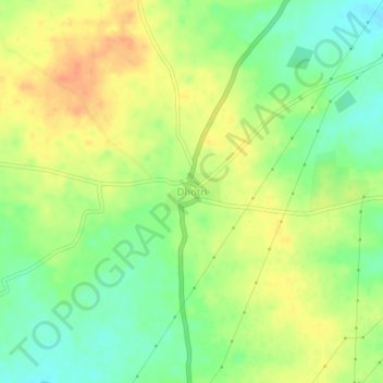
Name: Dhotri topographic map, elevation, terrain.

Location: Dhotri, Solapur South, Solapur District, Maharashtra, India (17.65508 76.06569 17.69508 76.10569)

Average elevation: 1,673 ft

Minimum elevation: 1,601 ft

Maximum elevation: 1,742 ft

Other topographic maps

Click on a map to view its topography, its elevation and its terrain.

Musti

India > Maharashtra > Solapur South

Musti, Solapur South, Solapur District, Maharashtra, 413573, India

Average elevation: 1,598 ft

Akole

India > Maharashtra > Solapur South

Akole, Solapur South, Solapur, Maharashtra, India

Average elevation: 1,457 ft