
Thank you for supporting this site ❤️
Make a donation
Make a donation
Gear up for your next adventure:
As an Amazon Associate, this site earns from qualifying purchases at no extra cost to you.
Schönenborn topographic map
Click on the map to display elevation.
Thank you for supporting this site ❤️
Make a donation
Make a donation
Gear up for your next adventure:
As an Amazon Associate, this site earns from qualifying purchases at no extra cost to you.
Schönenborn
Schönenborn liegt im westlichen Lindlar nahe der größeren Ortschaft Schmitzhöhe an der Kreisstraße 20. Weitere Nachbarorte sind Sieferhof, Holl, Köttingen, Leienhöhe, Kalkofen und Berghausen.
Thank you for supporting this site ❤️
Make a donation
Make a donation
Gear up for your next adventure:
As an Amazon Associate, this site earns from qualifying purchases at no extra cost to you.
About this map
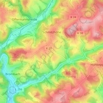
Name: Schönenborn topographic map, elevation, terrain.
Average elevation: 620 ft
Minimum elevation: 331 ft
Maximum elevation: 879 ft
Thank you for supporting this site ❤️
Make a donation
Make a donation
Gear up for your next adventure:
As an Amazon Associate, this site earns from qualifying purchases at no extra cost to you.