
Make a donation
Gear up for your next adventure:
As an Amazon Associate, this site earns from qualifying purchases at no extra cost to you.
Balma de s'Estepa Negra topographic map
Click on the map to display elevation.
Make a donation
Gear up for your next adventure:
As an Amazon Associate, this site earns from qualifying purchases at no extra cost to you.
About this map
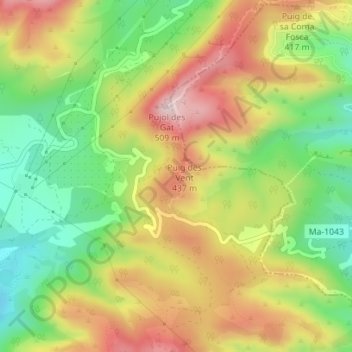
Name: Balma de s'Estepa Negra topographic map, elevation, terrain.
Average elevation: 1,033 ft
Minimum elevation: 489 ft
Maximum elevation: 1,637 ft
Make a donation
Gear up for your next adventure:
As an Amazon Associate, this site earns from qualifying purchases at no extra cost to you.
Other topographic maps
Click on a map to view its topography, its elevation and its terrain.
Valldemossa
Spanje > Balearen > Serra de Tramuntana
Valldemossa is een gemeente in de Spaanse provincie en regio Balearen met een oppervlakte van 43 km². Valldemossa heeft 2042 inwoners (2021). Het bergdorp ligt in een vallei op het eiland Mallorca, op een hoogte van 420 meter boven de zeespiegel. De plaats is internationaal bekend door het verblijf (ruim 3…
Average elevation: 1,181 ft
Pollença
Spanje > Balearen > Serra de Tramuntana
Deze weinig toeristische provinciestad ligt met het strand in de rug naar het donkere gebergte van de Tenelles toegewend. Inwoners uit Alcudia, die in de 14e eeuw voor de voortdurende overvallen van de piraten landinwaarts waren gevlucht, gaven de stad de naam van de oude Romeinse nederzetting Pollentia.…
Average elevation: 377 ft