
Thank you for supporting this site ❤️
Make a donation
Make a donation
Gear up for your next adventure:
As an Amazon Associate, this site earns from qualifying purchases at no extra cost to you.
Gopi Rai topographic map
Click on the map to display elevation.
Thank you for supporting this site ❤️
Make a donation
Make a donation
Gear up for your next adventure:
As an Amazon Associate, this site earns from qualifying purchases at no extra cost to you.
About this map
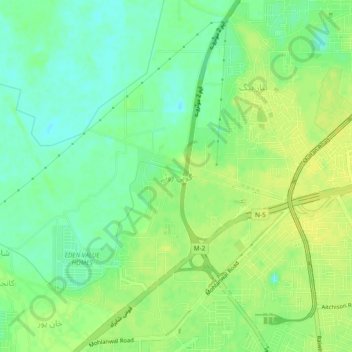
Name: Gopi Rai topographic map, elevation, terrain.
Location: Gopi Rai, Lahore District, Punjab, 53700, Pakistan (31.45419 74.20611 31.49419 74.24611)
Average elevation: 679 ft
Minimum elevation: 646 ft
Maximum elevation: 702 ft
Thank you for supporting this site ❤️
Make a donation
Make a donation
Gear up for your next adventure:
As an Amazon Associate, this site earns from qualifying purchases at no extra cost to you.