Geolocate

Weno topographic map

Interactive map

Click on the map to display elevation.

About this map

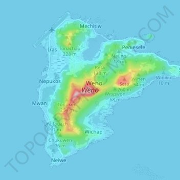
Name: Weno topographic map, elevation, terrain.

Location: Weno, Chuuk, 96942, Federated States of Micronesia (7.41165 151.83608 7.46864 151.90149)

Average elevation: 82 ft

Minimum elevation: -7 ft

Maximum elevation: 1,181 ft

The highest point is Mount Teroken, elevation 364 m (1,214 ft).

Wikipedia (CC-BY-SA 3.0)

Other topographic maps

Click on a map to view its topography, its elevation and its terrain.

Atkin

Federated States of Micronesia > Chuuk

Atkin, Chuuk, Federated States of Micronesia

Average elevation: 3 ft

Truk Lagoon

Federated States of Micronesia > Chuuk

Truk Lagoon, Chuuk, Federated States of Micronesia

Average elevation: 0 ft

Nomwin Atoll

Federated States of Micronesia > Chuuk

Nomwin Atoll, Chuuk, Federated States of Micronesia

Average elevation: 0 ft

Nachu

Federated States of Micronesia > Chuuk

Nachu, Chuuk, Federated States of Micronesia

Average elevation: 3 ft