Geolocate

Lages topographic map

Click on the map to display elevation.

About this map
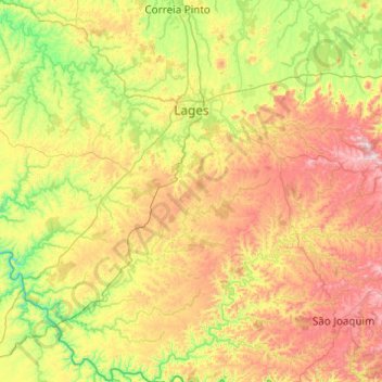
Name: Lages topographic map, elevation, terrain.

Location: Lages, Santa Catarina, South Region, Brazil (-28.43334 -50.69641 -27.56908 -49.99821)

Average elevation: 3,317 ft

Minimum elevation: 2,070 ft

Maximum elevation: 5,646 ft

Other topographic maps

Click on a map to view its topography, its elevation and its terrain.
Três Picos

Brazil > Santa Catarina

Average elevation: 2,608 ft

Residência Fuck

Brazil > Santa Catarina > Monte Castelo

Average elevation: 2,772 ft

Córrego do Fuck

Brazil > Santa Catarina > Canoinhas

Average elevation: 2,579 ft

Serra da Bateia

Brazil > Santa Catarina > Guabiruba

Average elevation: 1,112 ft

Alto Pitanga

Brazil > Santa Catarina > Nova Trento

Average elevation: 1,401 ft

Palhocinha

Brazil > Santa Catarina > Trombudo Central

Average elevation: 1,283 ft

Pericó

Brazil > Santa Catarina > São Joaquim

Average elevation: 4,065 ft

Gear up for your next adventure:

🔌Solar Panel Charger - Charge gear sustainably outdoors
⛑️Personal Locator Beacon - Safety beacon for emergencies
🪶Thermal Camp Blanket - Extra warmth for cold nights
🕶️GPS Smartphone Mount - Secure mount for phone navigation
🧥Waterproof Jacket for Hiking - Breathable and rugged rain jacket for outdoor excursions

As an Amazon Associate, this site earns from qualifying purchases at no extra cost to you.