Geolocate

Tow topographic map

Click on the map to display elevation.

About this map

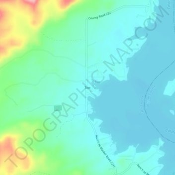
Name: Tow topographic map, elevation, terrain.

Location: Tow, Llano County, Texas, 78672, United States (30.86351 -98.49253 30.90351 -98.45253)

Average elevation: 1,099 ft

Minimum elevation: 1,004 ft

Maximum elevation: 1,453 ft

Llano County trails, hiking, mountain biking, running and outdoor activities

Other topographic maps

Click on a map to view its topography, its elevation and its terrain.

Llano

United States > Texas > Llano County

Average elevation: 1,070 ft

Gear up for your next adventure:

🦶Carbon Trekking Poles - Reduce knee impact on steep descents with ultra-light poles
📷Action Camera - Capture your outdoor adventures in HD
🕶️Glacier Sunglasses - Side shields to protect eyes from high-altitude snow glare
🪵Folding Camp Saw - Compact saw for wood and campsite work
🏕️Tent Footprint - Protect your tent base from wear

As an Amazon Associate, this site earns from qualifying purchases at no extra cost to you.