
Kommern topographic map
Click on the map to display elevation.
About this map
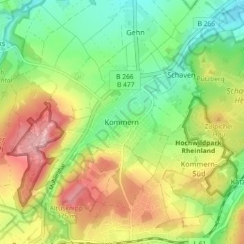
Name: Kommern topographic map, elevation, terrain.
Average elevation: 928 ft
Minimum elevation: 712 ft
Maximum elevation: 1,217 ft
Other topographic maps
Click on a map to view its topography, its elevation and its terrain.
Angelteiche Feyermühle
Deutschland > Nordrhein-Westfalen > Kreis Euskirchen > Mechernich > Breitenbenden > Burgfey
Average elevation: 1,024 ft
Bescheid
Deutschland > Nordrhein-Westfalen > Kreis Euskirchen > Mechernich > Bleibuir
Average elevation: 1,201 ft