Geolocate
👉 Easily get elevation data in JSON, GeoTIFF and KML formats using Elevation API
Thank you for supporting this site ❤️
Make a donation

Schurwald topographic map

Click on the map to display elevation.

About this map

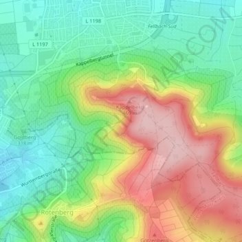
Name: Schurwald topographic map, elevation, terrain.

Location: Schurwald, Fellbach, Rems-Murr-Kreis, Baden-Württemberg, 70734, Deutschland (48.79076 9.27815 48.79612 9.28525)

Average elevation: 1,178 ft

Minimum elevation: 902 ft

Maximum elevation: 1,572 ft

Other topographic maps

Click on a map to view its topography, its elevation and its terrain.

Gear up for your next adventure:

🧦Hiking Socks - Comfortable socks to prevent blisters on long hikes
🧤Hiking Gloves - Protective gloves for rugged trails
🪄Magnetic Compass - Accurate compass for navigation
🎒Trekking Poles - Sturdy poles for balance and stability on rough terrain
⛑️Personal Locator Beacon - Safety beacon for emergencies

As an Amazon Associate, this site earns from qualifying purchases at no extra cost to you.