Geolocate

Feldkirchen topographic map

Click on the map to display elevation.

About this map
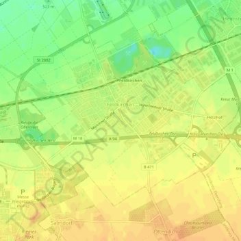
Name: Feldkirchen topographic map, elevation, terrain.

Location: Feldkirchen, Landkreis München, Bavaria, 85622, Germany (48.13266 11.70505 48.15770 11.75798)

Average elevation: 1,722 ft

Minimum elevation: 1,657 ft

Maximum elevation: 1,759 ft

Other topographic maps

Click on a map to view its topography, its elevation and its terrain.
Eglfing

Germany > Bavaria > Landkreis München > Haar

Average elevation: 1,772 ft

Martinsried

Germany > Bavaria > Landkreis München > Planegg

Average elevation: 1,801 ft

Hofolding

Germany > Bavaria > Landkreis München

Average elevation: 1,998 ft

Holzhausen

Germany > Bavaria > Landkreis München

Average elevation: 2,175 ft

Deisenhofen

Germany > Bavaria > Landkreis München > Oberhaching

Average elevation: 1,942 ft

Gear up for your next adventure:

🔥Plasma Lighters - Windproof lighters that work in any weather condition
🌐World Map Poster - Decorative world maps with topographic info
🥩Freeze-Dried Meals - Nutritious and lightweight food for remote expeditions
🧥Waterproof Jacket for Hiking - Breathable and rugged rain jacket for outdoor excursions
📡GPS Antenna Upgrade - Enhance GPS reception in remote terrain

As an Amazon Associate, this site earns from qualifying purchases at no extra cost to you.