
Brazeau River Provincial Recreation Area topographic map
Interactive map
Click on the map to display elevation.
About this map
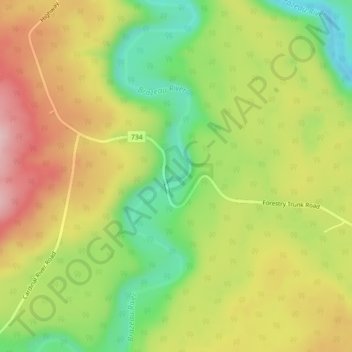
Name: Brazeau River Provincial Recreation Area topographic map, elevation, terrain.
Average elevation: 4,347 ft
Minimum elevation: 3,996 ft
Maximum elevation: 4,701 ft
Other topographic maps
Click on a map to view its topography, its elevation and its terrain.
Brule
Canada > Alberta > Yellowhead County
Brule, Yellowhead County, Alberta, Canada
Average elevation: 3,724 ft
Rock Lake Provincial Park
Canada > Alberta > Yellowhead County
Rock Lake Provincial Park, Yellowhead County, Alberta, Canada
Average elevation: 5,289 ft
Yates Natural Area
Canada > Alberta > Yellowhead County
Yates Natural Area, Township Road 534, Yellowhead County, Alberta, Canada
Average elevation: 2,887 ft
Peers
Canada > Alberta > Yellowhead County
Peers, Yellowhead County, Alberta, Canada
Average elevation: 2,789 ft
Fairfax Lake
Canada > Alberta > Yellowhead County
Fairfax Lake, Yellowhead County, Alberta, Canada
Average elevation: 4,419 ft
Folding Mountain
Canada > Alberta > Yellowhead County
Folding Mountain, Yellowhead County, Alberta, Canada
Average elevation: 5,925 ft
Robb
Canada > Alberta > Yellowhead County
Robb, Yellowhead County, Alberta, Canada
Average elevation: 3,747 ft