Geolocate

Alnavar topographic map

Click on the map to display elevation.

Alnavar

Alnavar is located at 15°26′N 74°44′E / 15.43°N 74.73°E / 15.43; 74.73. It has an average elevation of 563 metres (1847 feet). Trains from Bangalore to Vasco da Gama passes through this town.

Wikipedia (CC-BY-SA 3.0)

About this map

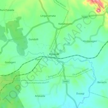
Name: Alnavar topographic map, elevation, terrain.

Location: Alnavar, Alnavara taluku, Dharwad, Karnataka, India (15.38719 74.69839 15.46719 74.77839)

Average elevation: 1,886 ft

Minimum elevation: 1,755 ft

Maximum elevation: 2,336 ft

Gear up for your next adventure:

🔊Portable Camp Speaker - Music and alerts at camp
📱Solar Portable Charger - Solar power bank for charging devices off‑grid
😴Insulated Sleeping Pads - Compact and warm pads for high-elevation camping
🔋Solar Power Banks - Keep your GPS and phone charged in remote wilderness areas
🧭Pro Hiking Compasses - High-accuracy liquid-filled compasses for topographic orientation

As an Amazon Associate, this site earns from qualifying purchases at no extra cost to you.