
St. Matthews topographic map
Click on the map to display elevation.
About this map
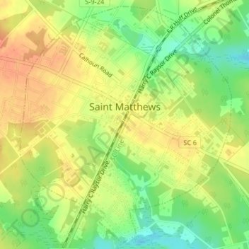
Name: St. Matthews topographic map, elevation, terrain.
Location: St. Matthews, Calhoun County, South Carolina, United States (33.65002 -80.79153 33.67573 -80.76395)
Average elevation: 269 ft
Minimum elevation: 190 ft
Maximum elevation: 328 ft
Calhoun County trails, hiking, mountain biking, running and outdoor activities
Other topographic maps
Click on a map to view its topography, its elevation and its terrain.