
Make a donation
Gear up for your next adventure:
As an Amazon Associate, this site earns from qualifying purchases at no extra cost to you.
Selva Candida topographic map
Click on the map to display elevation.
Make a donation
Gear up for your next adventure:
As an Amazon Associate, this site earns from qualifying purchases at no extra cost to you.
About this map
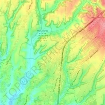
Name: Selva Candida topographic map, elevation, terrain.
Location: Selva Candida, Roma, Lazio, 00166, Italia (41.93341 12.35832 41.97341 12.39832)
Average elevation: 305 ft
Minimum elevation: 148 ft
Maximum elevation: 486 ft
Make a donation
Gear up for your next adventure:
As an Amazon Associate, this site earns from qualifying purchases at no extra cost to you.
Other topographic maps
Click on a map to view its topography, its elevation and its terrain.
Riserva Naturale del Laurentino - Acqua Acetosa
Italia > Lazio > Roma > Roma > Mostacciano
Average elevation: 112 ft
Make a donation
Gear up for your next adventure:
As an Amazon Associate, this site earns from qualifying purchases at no extra cost to you.
Make a donation
Gear up for your next adventure:
As an Amazon Associate, this site earns from qualifying purchases at no extra cost to you.