Geolocate

Casperia topographic map

Click on the map to display elevation.

About this map
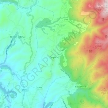
Name: Casperia topographic map, elevation, terrain.

Location: Casperia, Rieti, Lazio, Italy (42.31308 12.63838 42.37066 12.73285)

Average elevation: 1,450 ft

Minimum elevation: 456 ft

Maximum elevation: 4,114 ft

Other topographic maps

Click on a map to view its topography, its elevation and its terrain.
Monte Terminillo

Italy > Lazio > Rieti > Micigliano

Monte Terminillo is a massif in the Monti Reatini, part of the Abruzzi Apennine range in central Italy. It is located some 20 km from Rieti and 100 km from Rome and has a highest altitude of 2,217 metres (7,274 ft).

Average elevation: 6,017 ft

Vasche

Italy > Lazio > Rieti > Terme di Cotilia

Average elevation: 2,215 ft

Terria

Italy > Lazio > Rieti > Contigliano

Average elevation: 1,283 ft

Tonnicoda

Italy > Lazio > Rieti > Pescorocchiano

Average elevation: 2,615 ft

Monticchio

Italy > Lazio > Rieti > Monte San Giovanni in Sabina

Average elevation: 2,552 ft

Apoleggia

Italy > Lazio > Rieti > Rivodutri

Average elevation: 1,713 ft

Laghetto della Croce o della Guardia

Italy > Lazio > Rieti > Leonessa

Average elevation: 4,741 ft

Colle San Pastore

Italy > Lazio > Rieti > Rieti

Average elevation: 1,247 ft

Pian de' Valli

Italy > Lazio > Rieti > Rieti

Average elevation: 5,016 ft

Poggio Fidoni

Italy > Lazio > Rieti > Rieti

Average elevation: 1,827 ft

Gear up for your next adventure:

🎒Day Hiking Backpack - Lightweight backpack perfect for day trips and outdoor adventures
📷Action Camera - Capture your outdoor adventures in HD
🪶Paracord Bracelet - Survival bracelet with built‑in tools
🧭Outdoor Navigation Book - Learn advanced navigation skills
🛡️Insect Repellent - Protection against bugs during outdoor activities

As an Amazon Associate, this site earns from qualifying purchases at no extra cost to you.