
Make a donation
Gear up for your next adventure:
As an Amazon Associate, this site earns from qualifying purchases at no extra cost to you.
Lake Thun topographic map
Click on the map to display elevation.
Make a donation
Gear up for your next adventure:
As an Amazon Associate, this site earns from qualifying purchases at no extra cost to you.
About this map
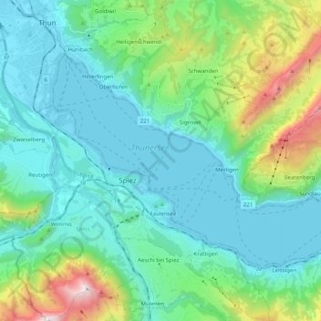
Name: Lake Thun topographic map, elevation, terrain.
Location: Lake Thun, Oberland administrative region, Bern, Switzerland (46.65524 7.63158 46.74515 7.82883)
Average elevation: 3,012 ft
Minimum elevation: 1,808 ft
Maximum elevation: 7,713 ft
Make a donation
Gear up for your next adventure:
As an Amazon Associate, this site earns from qualifying purchases at no extra cost to you.
Other topographic maps
Click on a map to view its topography, its elevation and its terrain.
Titlis
Switzerland > Bern > Interlaken-Oberhasli administrative district > Innertkirchen
Average elevation: 8,268 ft
Oberdettigen
Switzerland > Bern > Bern-Mittelland administrative district > Hinterkappelen
Average elevation: 1,857 ft
Schilthorn
Switzerland > Bern > Interlaken-Oberhasli administrative district > Lauterbrunnen
Average elevation: 8,054 ft
Devis
Switzerland > Bern > Frutigen-Niedersimmental administrative district > Kandergrund > Reckental
Average elevation: 3,635 ft
Make a donation
Gear up for your next adventure:
As an Amazon Associate, this site earns from qualifying purchases at no extra cost to you.
Burglauenen
Switzerland > Bern > Interlaken-Oberhasli administrative district > Grindelwald
Average elevation: 4,616 ft
Kiental
Switzerland > Bern > Frutigen-Niedersimmental administrative district > Reichenbach im Kandertal
Average elevation: 4,472 ft
Brienz
Switzerland > Bern > Interlaken-Oberhasli administrative district > Brienz (BE)
Average elevation: 2,657 ft
Make a donation
Gear up for your next adventure:
As an Amazon Associate, this site earns from qualifying purchases at no extra cost to you.
Glacier de la Plaine Morte
Switzerland > Bern > Obersimmental-Saanen administrative district > Mollens (VS)
Average elevation: 8,770 ft
Rindsbach
Switzerland > Bern > Emmental administrative district > Signau > Rindsbach
Average elevation: 2,448 ft
Ballenberg
Switzerland > Bern > Interlaken-Oberhasli administrative district > Hofstetten bei Brienz > Hofstetten
Average elevation: 2,539 ft
Bern
Switzerland > Bern > Bern-Mittelland administrative district > Bern
Bern is built on very uneven ground. An elevation difference of up to 60 metres exists between the inner city districts on the Aare (Matte, Marzili) and the higher ones (Kirchenfeld, Länggasse).
Average elevation: 2,110 ft
Make a donation
Gear up for your next adventure:
As an Amazon Associate, this site earns from qualifying purchases at no extra cost to you.
Hofen
Switzerland > Bern > Bern-Mittelland administrative district > Wohlen bei Bern
Average elevation: 1,867 ft
Gmünde
Switzerland > Bern > Emmental administrative district > Langnau im Emmental
Average elevation: 3,323 ft
Wellhorn
Switzerland > Bern > Interlaken-Oberhasli administrative district > Schattenhalb
Average elevation: 8,156 ft