Geolocate

Charco topographic map

Click on the map to display elevation.

About this map

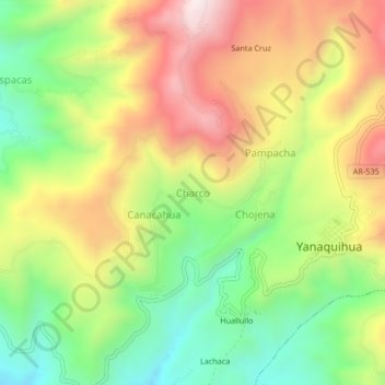
Name: Charco topographic map, elevation, terrain.

Location: Charco, Yanaquihua, Condesuyos, Arequipa, Peru (-15.79019 -72.91128 -15.75019 -72.87128)

Average elevation: 9,836 ft

Minimum elevation: 8,668 ft

Maximum elevation: 11,204 ft

Gear up for your next adventure:

🎒Hydration Pack - Hands‑free water reservoir for long hikes
🌄Hiking Binoculars - Compact binoculars for scenic views and trail spotting
🪶LED Camping Lantern - Bright lantern for camp lighting
📡GPS Antenna Upgrade - Enhance GPS reception in remote terrain
🪶Trail Camera - Capture wildlife on your hikes

As an Amazon Associate, this site earns from qualifying purchases at no extra cost to you.