Geolocate

Niesky topographic map

Click on the map to display elevation.

About this map

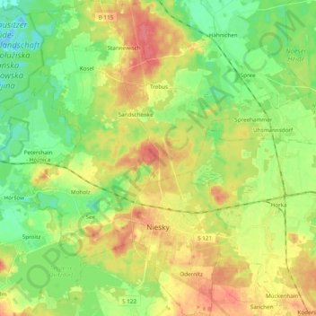
Name: Niesky topographic map, elevation, terrain.

Location: Niesky, Görlitz - Zhorjelc, Saxony, 02906, Germany (51.25824 14.74908 51.37804 14.86830)

Average elevation: 541 ft

Minimum elevation: 456 ft

Maximum elevation: 646 ft

Other topographic maps

Click on a map to view its topography, its elevation and its terrain.

Gear up for your next adventure:

🪓Survival Multi‑Tool - Versatile tool for camp and trail tasks
🪶Compact Camp Shovel - Folding shovel for campsite tasks
🪶Paracord Bracelet - Survival bracelet with built‑in tools
🏕️Tent Footprint - Protect your tent base from wear
📡Handheld GPS Device - Reliable handheld GPS for outdoor navigation

As an Amazon Associate, this site earns from qualifying purchases at no extra cost to you.