Geolocate

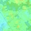
Croix Izan topographic map

Click on the map to display elevation.

About this map

Name: Croix Izan topographic map, elevation, terrain.

Location: Croix Izan, Erdeven, Lorient, Morbihan, Bretagne, France métropolitaine, 56410, France (47.63468 -3.21071 47.67468 -3.17071)

Average elevation: 30 ft

Minimum elevation: -13 ft

Maximum elevation: 62 ft

Other topographic maps

Click on a map to view its topography, its elevation and its terrain.
Quadrilatère de Crucuno

France > Bretagne > Morbihan > Erdeven > Crucuno

Average elevation: 59 ft

56410

France > Bretagne > Morbihan > Erdeven

Average elevation: 43 ft

Gear up for your next adventure:

🧺Microfiber Travel Towels - Compact and fast-drying towels for trail use
🔦Powerful Headlamps - Ultra-bright hands-free lighting for night navigation
🥩Freeze-Dried Meals - Nutritious and lightweight food for remote expeditions
🥤Water Filter Bottle - All‑in‑one filter bottle for safe hydration
📌Outdoor GPS Map App - Apps and devices for digital topographic navigation

As an Amazon Associate, this site earns from qualifying purchases at no extra cost to you.