
Thank you for supporting this site ❤️
Make a donation
Make a donation
Gear up for your next adventure:
As an Amazon Associate, this site earns from qualifying purchases at no extra cost to you.
Jiangnan topographic map
Click on the map to display elevation.
Thank you for supporting this site ❤️
Make a donation
Make a donation
Gear up for your next adventure:
As an Amazon Associate, this site earns from qualifying purchases at no extra cost to you.
About this map
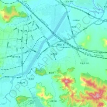
Name: Jiangnan topographic map, elevation, terrain.
Location: Jiangnan, Dunhua City, Yanbian, Jilin, China (43.35091 128.21981 43.43091 128.29981)
Average elevation: 1,713 ft
Minimum elevation: 1,568 ft
Maximum elevation: 2,087 ft
Thank you for supporting this site ❤️
Make a donation
Make a donation
Gear up for your next adventure:
As an Amazon Associate, this site earns from qualifying purchases at no extra cost to you.