
Mitterberg topographic map
Interactive map
Click on the map to display elevation.
About this map
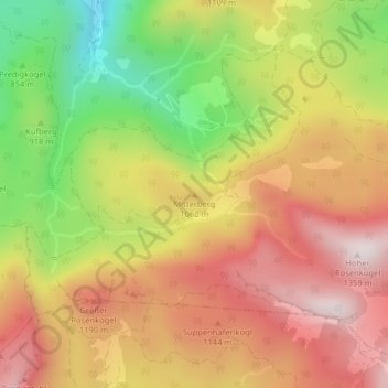
Name: Mitterberg topographic map, elevation, terrain.
Location: Mitterberg, Bad Ischl, Bezirk Gmunden, 4820, Österreich (47.67260 13.65663 47.67270 13.65673)
Average elevation: 3,284 ft
Minimum elevation: 2,021 ft
Maximum elevation: 4,301 ft
Other topographic maps
Click on a map to view its topography, its elevation and its terrain.
Sulzbach
Österreich > Bezirk Gmunden > Bad Ischl > Eck
Sulzbach, Eck, Bad Ischl, Bezirk Gmunden, 4820, Österreich
Average elevation: 2,090 ft
Reiterndorf
Österreich > Bezirk Gmunden > Bad Ischl
Reiterndorf, Bad Ischl, Bezirk Gmunden, 4820, Österreich
Average elevation: 1,972 ft