Geolocate

Gammaduwa topographic map

Click on the map to display elevation.

About this map

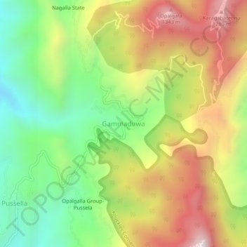
Name: Gammaduwa topographic map, elevation, terrain.

Location: Gammaduwa, Matale District, Central Province, Sri Lanka (7.55135 80.67761 7.59135 80.71761)

Average elevation: 2,753 ft

Minimum elevation: 1,316 ft

Maximum elevation: 4,469 ft

Other topographic maps

Click on a map to view its topography, its elevation and its terrain.

Upper Kotmale Dam

Sri Lanka > Central Province > Talawakele > Holyrood

Average elevation: 4,098 ft

Matale District

Sri Lanka > Central Province

Average elevation: 886 ft

Nuwara Eliya District

Sri Lanka > Central Province

Average elevation: 3,586 ft

Pitawala Pathana

Sri Lanka > Central Province

Average elevation: 2,421 ft

Canyon Dam

Sri Lanka > Central Province > Hapugastenne

Average elevation: 3,615 ft

Sigiriya

Sri Lanka > Central Province

Average elevation: 666 ft

Gear up for your next adventure:

📷Action Camera - Capture your outdoor adventures in HD
👓Polarized Sunglasses - Outdoor sunglasses for glare reduction
🧭Hiking Compass - Precision compass for reliable navigation in the wilderness
👟Trail Running Shoes - Lightweight shoes for trail runners
🔥Plasma Lighters - Windproof lighters that work in any weather condition

As an Amazon Associate, this site earns from qualifying purchases at no extra cost to you.