Geolocate

Waterloo topographic map

Click on the map to display elevation.

About this map

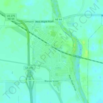
Name: Waterloo topographic map, elevation, terrain.

Location: Waterloo, Douglas County, Nebraska, United States (41.27749 -96.29418 41.29294 -96.27694)

Average elevation: 1,125 ft

Minimum elevation: 1,109 ft

Maximum elevation: 1,145 ft

Douglas County trails, hiking, mountain biking, running and outdoor activities

Other topographic maps

Click on a map to view its topography, its elevation and its terrain.

Venice

United States > Nebraska > Douglas County

Average elevation: 1,132 ft

Omaha

United States > Nebraska > Douglas County > Omaha

Average elevation: 1,112 ft

Irvington

United States > Nebraska > Douglas County > Omaha

Average elevation: 1,165 ft

Devil's Slide

United States > Nebraska > Douglas County > Omaha

Average elevation: 1,063 ft

King Lake

United States > Nebraska > Douglas County > King Lake

Average elevation: 1,132 ft

Memorial Park

United States > Nebraska > Douglas County > Omaha

Average elevation: 1,161 ft

Gear up for your next adventure:

GPS Sports Watch - GPS watch for running, hiking and training
🔊Portable Camp Speaker - Music and alerts at camp
🛠️Outdoor Gear Repair Kit - Essential tools to fix gear on the trail
🪶Thermal Camp Blanket - Extra warmth for cold nights
🦶Carbon Trekking Poles - Reduce knee impact on steep descents with ultra-light poles

As an Amazon Associate, this site earns from qualifying purchases at no extra cost to you.