
Thank you for supporting this site ❤️
Make a donation
Make a donation
Gear up for your next adventure:
As an Amazon Associate, this site earns from qualifying purchases at no extra cost to you.
Bogatynia topographic map
Click on the map to display elevation.
Thank you for supporting this site ❤️
Make a donation
Make a donation
Gear up for your next adventure:
As an Amazon Associate, this site earns from qualifying purchases at no extra cost to you.
About this map
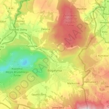
Name: Bogatynia topographic map, elevation, terrain.
Average elevation: 938 ft
Minimum elevation: 125 ft
Maximum elevation: 1,834 ft
Thank you for supporting this site ❤️
Make a donation
Make a donation
Gear up for your next adventure:
As an Amazon Associate, this site earns from qualifying purchases at no extra cost to you.
Other topographic maps
Click on a map to view its topography, its elevation and its terrain.
Pop
Poland > Lower Silesian Voivodeship > Zgorzelec County > Studniska Dolne
Average elevation: 712 ft
Szklana Góra
Poland > Lower Silesian Voivodeship > Zgorzelec County > Stary Węgliniec
Average elevation: 702 ft