
Thank you for supporting this site ❤️
Make a donation
Make a donation
Gear up for your next adventure:
As an Amazon Associate, this site earns from qualifying purchases at no extra cost to you.
Castelo topographic map
Click on the map to display elevation.
Thank you for supporting this site ❤️
Make a donation
Make a donation
Gear up for your next adventure:
As an Amazon Associate, this site earns from qualifying purchases at no extra cost to you.
About this map
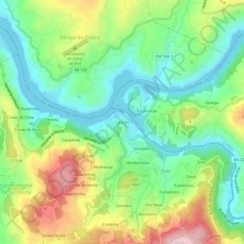
Name: Castelo topographic map, elevation, terrain.
Location: Castelo, Fornos, Castelo de Paiva, Aveiro, 4550-100, Portugal (41.04356 -8.28147 41.08356 -8.24147)
Average elevation: 410 ft
Minimum elevation: 33 ft
Maximum elevation: 1,073 ft
Thank you for supporting this site ❤️
Make a donation
Make a donation
Gear up for your next adventure:
As an Amazon Associate, this site earns from qualifying purchases at no extra cost to you.