
Make a donation
Gear up for your next adventure:
As an Amazon Associate, this site earns from qualifying purchases at no extra cost to you.
Rome topographic map
Click on the map to display elevation.
Make a donation
Gear up for your next adventure:
As an Amazon Associate, this site earns from qualifying purchases at no extra cost to you.
About this map
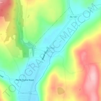
Name: Rome topographic map, elevation, terrain.
Location: Rome, Bradford County, Pennsylvania, United States (41.84581 -76.35160 41.86860 -76.33084)
Average elevation: 1,030 ft
Minimum elevation: 794 ft
Maximum elevation: 1,365 ft
Bradford County trails, hiking, mountain biking, running and outdoor activities
Make a donation
Gear up for your next adventure:
As an Amazon Associate, this site earns from qualifying purchases at no extra cost to you.
Other topographic maps
Click on a map to view its topography, its elevation and its terrain.
North Towanda
United States > Pennsylvania > Bradford County > North Towanda Township
Average elevation: 938 ft
Owl Hollow
United States > Pennsylvania > Bradford County > Windham Township
Average elevation: 1,178 ft
Gillett
United States > Pennsylvania > Bradford County > South Creek Township
Average elevation: 1,542 ft
Make a donation
Gear up for your next adventure:
As an Amazon Associate, this site earns from qualifying purchases at no extra cost to you.
Allis Hollow
United States > Pennsylvania > Bradford County > Orwell Township
Average elevation: 1,142 ft
Stevensville
United States > Pennsylvania > Bradford County > Stevens Township
Average elevation: 1,076 ft
Bentley Creek
United States > Pennsylvania > Bradford County > Ridgebury Township
Average elevation: 1,368 ft
Springfield
United States > Pennsylvania > Bradford County > Springfield Township
Average elevation: 1,450 ft
Make a donation
Gear up for your next adventure:
As an Amazon Associate, this site earns from qualifying purchases at no extra cost to you.
Ridgebury
United States > Pennsylvania > Bradford County > Ridgebury Township
Average elevation: 1,293 ft
Camptown
United States > Pennsylvania > Bradford County > Wyalusing Township
Average elevation: 1,043 ft
Lake Nephawin
United States > Pennsylvania > Bradford County > Canton Township
Average elevation: 1,549 ft