
Thank you for supporting this site ❤️
Make a donation
Make a donation
Gear up for your next adventure:
As an Amazon Associate, this site earns from qualifying purchases at no extra cost to you.
Kagerplassen topographic map
Click on the map to display elevation.
Thank you for supporting this site ❤️
Make a donation
Make a donation
Gear up for your next adventure:
As an Amazon Associate, this site earns from qualifying purchases at no extra cost to you.
About this map
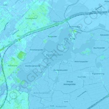
Name: Kagerplassen topographic map, elevation, terrain.
Location: Kagerplassen, Warmond, Teylingen, Zuid-Holland, Nederland (52.18703 4.50672 52.22122 4.60699)
Average elevation: -3 ft
Minimum elevation: -20 ft
Maximum elevation: 23 ft
Thank you for supporting this site ❤️
Make a donation
Make a donation
Gear up for your next adventure:
As an Amazon Associate, this site earns from qualifying purchases at no extra cost to you.