
Make a donation
Gear up for your next adventure:
As an Amazon Associate, this site earns from qualifying purchases at no extra cost to you.
Ocaña topographic map
Click on the map to display elevation.
Make a donation
Gear up for your next adventure:
As an Amazon Associate, this site earns from qualifying purchases at no extra cost to you.
Ocaña
Ocaña es un municipio colombiano ubicado en el departamento de Norte de Santander, al nororiente del país. Se encuentra dentro de la Subregión de Occidente en la región del Catatumbo, conocida coloquialmente como la Provincia de Ocaña. El municipio cuenta con una extensión de 672,27 km² y una altitud media de 1202 m s. n. m. Está ubicado al occidente del departamento, sobre la cordillera oriental y se encuentra atravesado por dos ríos: el Algodonal (nombre que recibe el río Catatumbo en el municipio) y el Tejo, además de varias quebradas.
Make a donation
Gear up for your next adventure:
As an Amazon Associate, this site earns from qualifying purchases at no extra cost to you.
About this map
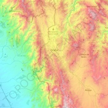
Name: Ocaña topographic map, elevation, terrain.
Average elevation: 3,806 ft
Minimum elevation: 262 ft
Maximum elevation: 8,570 ft
Make a donation
Gear up for your next adventure:
As an Amazon Associate, this site earns from qualifying purchases at no extra cost to you.
Other topographic maps
Click on a map to view its topography, its elevation and its terrain.
Make a donation
Gear up for your next adventure:
As an Amazon Associate, this site earns from qualifying purchases at no extra cost to you.