
Make a donation
Gear up for your next adventure:
As an Amazon Associate, this site earns from qualifying purchases at no extra cost to you.
Bermejo topographic map
Click on the map to display elevation.
Make a donation
Gear up for your next adventure:
As an Amazon Associate, this site earns from qualifying purchases at no extra cost to you.
Bermejo
Bermejo se encuentra situado a una altitud de 415 m s. n. m., con una temperatura media anual de 22,53 °C; sin embargo, el clima de Bermejo se caracteriza por tener temperaturas extremas: muy altas entre septiembre a mayo, llegando a alcanzar los 45 °C, mientras que entre junio a agosto las temperaturas descienden hasta los 10°.
Make a donation
Gear up for your next adventure:
As an Amazon Associate, this site earns from qualifying purchases at no extra cost to you.
About this map
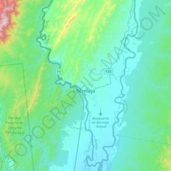
Name: Bermejo topographic map, elevation, terrain.
Location: Bermejo, Provincia Arce, Tarija, Bolivia (-22.87430 -64.44135 -22.56394 -64.23738)
Average elevation: 1,811 ft
Minimum elevation: 1,125 ft
Maximum elevation: 6,060 ft
Make a donation
Gear up for your next adventure:
As an Amazon Associate, this site earns from qualifying purchases at no extra cost to you.
Other topographic maps
Click on a map to view its topography, its elevation and its terrain.
Make a donation
Gear up for your next adventure:
As an Amazon Associate, this site earns from qualifying purchases at no extra cost to you.