Geolocate

Bethlehem topographic map

Click on the map to display elevation.

About this map

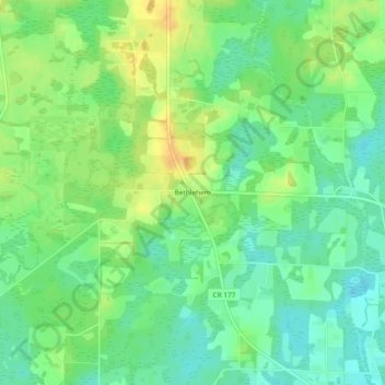
Name: Bethlehem topographic map, elevation, terrain.

Location: Bethlehem, Holmes County, Florida, United States (30.90463 -85.75910 30.94463 -85.71910)

Average elevation: 138 ft

Minimum elevation: 89 ft

Maximum elevation: 207 ft

Holmes County trails, hiking, mountain biking, running and outdoor activities

Other topographic maps

Click on a map to view its topography, its elevation and its terrain.

Noma

United States > Florida > Holmes County

Average elevation: 180 ft

Esto

United States > Florida > Holmes County

Average elevation: 197 ft

Bonifay

United States > Florida > Holmes County

Average elevation: 128 ft

Gear up for your next adventure:

🌧️Backpack Rain Cover - Keep gear dry in wet weather
👖Convertible Hiking Pants - Versatile zip-off pants for changing altitudes and temperatures
📦Dry Bags Set - Waterproof storage for electronics and clothes
📱Solar Portable Charger - Solar power bank for charging devices off‑grid
👟Men's Trail Runners - Lightweight footwear for fast-paced exploration and light hiking

As an Amazon Associate, this site earns from qualifying purchases at no extra cost to you.