
Make a donation
Gear up for your next adventure:
As an Amazon Associate, this site earns from qualifying purchases at no extra cost to you.
Kletzin topographic map
Click on the map to display elevation.
Make a donation
Gear up for your next adventure:
As an Amazon Associate, this site earns from qualifying purchases at no extra cost to you.
About this map
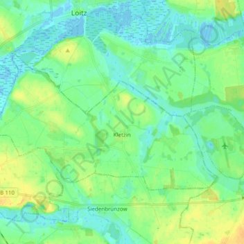
Name: Kletzin topographic map, elevation, terrain.
Average elevation: 26 ft
Minimum elevation: -16 ft
Maximum elevation: 69 ft
Make a donation
Gear up for your next adventure:
As an Amazon Associate, this site earns from qualifying purchases at no extra cost to you.
Other topographic maps
Click on a map to view its topography, its elevation and its terrain.
Strehlow
Deutschland > Mecklenburg-Vorpommern > Mecklenburgische Seenplatte > Hohenbrünzow
Average elevation: 135 ft
Törpin
Deutschland > Mecklenburg-Vorpommern > Mecklenburgische Seenplatte > Sarow
Average elevation: 177 ft
Loickenzin
Deutschland > Mecklenburg-Vorpommern > Mecklenburgische Seenplatte > Altentreptow > Loickenzin
Average elevation: 141 ft
Make a donation
Gear up for your next adventure:
As an Amazon Associate, this site earns from qualifying purchases at no extra cost to you.
Lindow
Deutschland > Mecklenburg-Vorpommern > Mecklenburgische Seenplatte > Lindow
Average elevation: 240 ft
Bresewitz
Deutschland > Mecklenburg-Vorpommern > Mecklenburgische Seenplatte > Friedland
Average elevation: 75 ft