
Make a donation
Gear up for your next adventure:
As an Amazon Associate, this site earns from qualifying purchases at no extra cost to you.
Much topographic map
Click on the map to display elevation.
Make a donation
Gear up for your next adventure:
As an Amazon Associate, this site earns from qualifying purchases at no extra cost to you.
About this map
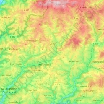
Name: Much topographic map, elevation, terrain.
Location: Much, Rhein-Sieg-Kreis, Noordrijn-Westfalen, 53804, Duitsland (50.84143 7.30311 50.94970 7.47930)
Average elevation: 745 ft
Minimum elevation: 325 ft
Maximum elevation: 1,247 ft
Make a donation
Gear up for your next adventure:
As an Amazon Associate, this site earns from qualifying purchases at no extra cost to you.
Other topographic maps
Click on a map to view its topography, its elevation and its terrain.
Aggertal
Duitsland > Noordrijn-Westfalen > Rhein-Sieg-Kreis > Lohmar > Neuhonrath > Hohnenberg
Average elevation: 535 ft
Krawinkel
Duitsland > Noordrijn-Westfalen > Rhein-Sieg-Kreis > Neunkirchen-Seelscheid > Birkenfeld
Average elevation: 620 ft
Make a donation
Gear up for your next adventure:
As an Amazon Associate, this site earns from qualifying purchases at no extra cost to you.
Drachenfels
Duitsland > Noordrijn-Westfalen > Rhein-Sieg-Kreis > Königswinter
De berg is met zijn hoogte van 321 meter een middelhoge berg. Door de legende van Siegfried, het kasteel en het slot, maar vooral door het weidse uitzicht vanaf de ruïne op de Rijn, is het een toeristische trekpleister.
Average elevation: 427 ft