
Make a donation
Gear up for your next adventure:
As an Amazon Associate, this site earns from qualifying purchases at no extra cost to you.
Ziegenhelle topographic map
Click on the map to display elevation.
Make a donation
Gear up for your next adventure:
As an Amazon Associate, this site earns from qualifying purchases at no extra cost to you.
Ziegenhelle
Die Ziegenhelle liegt im Hochsauerland, dem höchsten Teil des Rothaargebirges. Sie erhebt sich im Naturpark Sauerland-Rothaargebirge etwa 4 km südwestlich von Züschen, einem Stadtteil von Winterberg. Nordwestlich ihrer Kuppe entspringt die Ahre, südöstlich der Kuppe der Nuhne-Zufluss Bäche und auf ihrer Südwestflanke die Schwarzenau. Nordöstlich der Ziegenhelle, über deren Gipfel eine Loipe führt, breitet sich das Wintersportgebiet Snow World Züschen aus. Etwa 20 m nordwestlich vom Gipfel (815,9 m) liegt auf 815,5 m Höhe ein trigonometrischer Punkt.
Make a donation
Gear up for your next adventure:
As an Amazon Associate, this site earns from qualifying purchases at no extra cost to you.
About this map
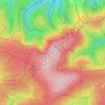
Name: Ziegenhelle topographic map, elevation, terrain.
Average elevation: 2,316 ft
Minimum elevation: 1,781 ft
Maximum elevation: 2,661 ft
Make a donation
Gear up for your next adventure:
As an Amazon Associate, this site earns from qualifying purchases at no extra cost to you.
Other topographic maps
Click on a map to view its topography, its elevation and its terrain.
Neger
Deutschland > Nordrhein-Westfalen > Hochsauerlandkreis > Winterberg
Die Neger entspringt im Rothaargebirge an der Nordwestflanke des Klappersbergs (729,9 m) auf einer Höhe von 722 m ü. NHN im Naturschutzgebiet Hömberg / Brusenbecke / Eberg / Kalte Spring. Ihre Quelle liegt etwa 1,5 km (Luftlinie) nordöstlich von Rehsiepen, einem Ortsteil von Schmallenberg. Sie fließt…
Average elevation: 1,929 ft