Geolocate

Semera topographic map

Click on the map to display elevation.

About this map

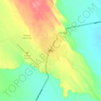
Name: Semera topographic map, elevation, terrain.

Location: Semera, Zone 1, Afar Region, 7240, Ethiopia (11.75231 40.96892 11.83231 41.04892)

Average elevation: 1,348 ft

Minimum elevation: 1,237 ft

Maximum elevation: 1,519 ft

Other topographic maps

Click on a map to view its topography, its elevation and its terrain.

water way

Ethiopia > Afar Region

Average elevation: 2,589 ft

Danakil Depression

Ethiopia > Afar Region

Average elevation: 479 ft

Zone 3

Ethiopia > Afar Region

Average elevation: 4,035 ft

Danakil Depression

Ethiopia > Afar Region

Average elevation: -344 ft

Mille

Ethiopia > Afar Region > Lower Miele

Average elevation: 1,627 ft

Gear up for your next adventure:

Camping Coffee Makers - Enjoy premium coffee at the summit or campsite
🧢Sun Protection Hats - Wide-brimmed and UPF-rated hats for high-altitude sun safety
🥩Freeze-Dried Meals - Nutritious and lightweight food for remote expeditions
🔌Solar Panel Charger - Charge gear sustainably outdoors
🛡️Insect Repellent - Protection against bugs during outdoor activities

As an Amazon Associate, this site earns from qualifying purchases at no extra cost to you.