
Make a donation
Gear up for your next adventure:
As an Amazon Associate, this site earns from qualifying purchases at no extra cost to you.
Giancos topographic map
Click on the map to display elevation.
Make a donation
Gear up for your next adventure:
As an Amazon Associate, this site earns from qualifying purchases at no extra cost to you.
About this map
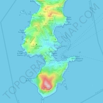
Name: Giancos topographic map, elevation, terrain.
Location: Giancos, Ponza, Latina, Lazio, 04027, Italia (40.87784 12.93827 40.91784 12.97827)
Average elevation: 75 ft
Minimum elevation: -13 ft
Maximum elevation: 925 ft
Make a donation
Gear up for your next adventure:
As an Amazon Associate, this site earns from qualifying purchases at no extra cost to you.
Other topographic maps
Click on a map to view its topography, its elevation and its terrain.
Isola di Ponza
Italia > Lazio > Latina > Ponza
Ponza ha una superficie di 7,5 km² ed è prevalentemente collinare. È sovrastata a nord dal monte Schiavone (157 m), al centro dai monti Core (201 m), Tre Venti (177 m) e Pagliaro (177 m) e raggiunge la massima altitudine con i 280 m del monte Guardia, posto esattamente all'estremità meridionale dell'isola.
Average elevation: 43 ft