Geolocate

Elstead topographic map

Click on the map to display elevation.

About this map

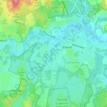
Name: Elstead topographic map, elevation, terrain.

Location: Elstead, Waverley, Surrey, England, United Kingdom (51.15839 -0.74597 51.20304 -0.68311)

Average elevation: 207 ft

Minimum elevation: 135 ft

Maximum elevation: 472 ft

Gear up for your next adventure:

🧢Outdoor Hiking Hat - Sun protection hat for outdoor explorers
🪶Paracord Bracelet - Survival bracelet with built‑in tools
🎒Trekking Poles - Sturdy poles for balance and stability on rough terrain
🔦Compact Flashlight - Reliable flashlight for emergencies
🍳Camping Cook Set - Complete cookware for outdoor meals

As an Amazon Associate, this site earns from qualifying purchases at no extra cost to you.