
Thank you for supporting this site ❤️
Make a donation
Make a donation
Gear up for your next adventure:
As an Amazon Associate, this site earns from qualifying purchases at no extra cost to you.
Usetxi topographic map
Click on the map to display elevation.
Thank you for supporting this site ❤️
Make a donation
Make a donation
Gear up for your next adventure:
As an Amazon Associate, this site earns from qualifying purchases at no extra cost to you.
About this map
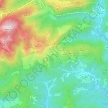
Name: Usetxi topographic map, elevation, terrain.
Location: Usetxi, Esteribar, Iruñerria, Navarre, 31630, Espagne (42.92851 -1.55882 42.96851 -1.51882)
Average elevation: 2,444 ft
Minimum elevation: 1,772 ft
Maximum elevation: 3,737 ft
Thank you for supporting this site ❤️
Make a donation
Make a donation
Gear up for your next adventure:
As an Amazon Associate, this site earns from qualifying purchases at no extra cost to you.
Other topographic maps
Click on a map to view its topography, its elevation and its terrain.