
Make a donation
Gear up for your next adventure:
As an Amazon Associate, this site earns from qualifying purchases at no extra cost to you.
Blockfelder am Taufstein topographic map
Click on the map to display elevation.
Make a donation
Gear up for your next adventure:
As an Amazon Associate, this site earns from qualifying purchases at no extra cost to you.
Blockfelder am Taufstein
Der Taufstein ist mit 773 m ü. NHN der höchste Gipfel im Vogelsberg. Er befindet sich bei Breungeshain im hessischen Vogelsbergkreis. Trotz einer beachtlichen Dominanz von 43 km und einer Schartenhöhe von 406 m fällt der Taufstein als Einzelberg kaum auf, da er aus der Gesamterhebung des Vogelsbergs nur wenig hervortritt. Auf ihm steht der 1910 fertiggestellte Bismarckturm.
Make a donation
Gear up for your next adventure:
As an Amazon Associate, this site earns from qualifying purchases at no extra cost to you.
About this map
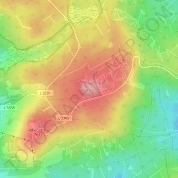
Name: Blockfelder am Taufstein topographic map, elevation, terrain.
Average elevation: 2,313 ft
Minimum elevation: 2,087 ft
Maximum elevation: 2,533 ft
Make a donation
Gear up for your next adventure:
As an Amazon Associate, this site earns from qualifying purchases at no extra cost to you.
Other topographic maps
Click on a map to view its topography, its elevation and its terrain.
Hoherodskopf
Deutschland > Hessen > Vogelsbergkreis > Breungeshain
Vom Gipfel des Hoherodskopfs bietet sich Fernsicht bis in das Rhein-Main-Gebiet und zum Taunus. Auf dem Westhang verläuft Hessens längster Skilift mit 1,2 km Länge, ein weiterer auf dem Südhang. Mehrere Loipen werden gespurt, auf der Ostseite befindet sich sogar eine mit Flutlicht (für Diagonal- und…
Average elevation: 2,231 ft