Wall topographic map
Interactive map
Click on the map to display elevation.
About this map
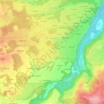
Name: Wall topographic map, elevation, terrain.
Location: Wall, Warngau, Landkreis Miesbach, Bayern, 83627, Deutschland (47.76921 11.75061 47.80921 11.79061)
Average elevation: 2,408 ft
Minimum elevation: 2,113 ft
Maximum elevation: 2,697 ft
Other topographic maps
Click on a map to view its topography, its elevation and its terrain.
Burgweg
Deutschland > Bayern > Landkreis Miesbach > Warngau > Bernloh
Burgweg, Bernloh, Warngau, Landkreis Miesbach, Bayern, 83627, Deutschland
Average elevation: 2,490 ft
Loch
Deutschland > Bayern > Landkreis Miesbach > Warngau > Wall
Loch, Wall, Warngau, Landkreis Miesbach, Bayern, 83627, Deutschland
Average elevation: 2,405 ft