
Make a donation
Gear up for your next adventure:
As an Amazon Associate, this site earns from qualifying purchases at no extra cost to you.
Mont-aux-Sources topographic map
Click on the map to display elevation.
Make a donation
Gear up for your next adventure:
As an Amazon Associate, this site earns from qualifying purchases at no extra cost to you.
Mont-aux-Sources
The Mont-Aux-Sources is part of a basalt plateau which lies at an average elevation of about 3,050 meters (10 000 ft). Among the many escarpments that surround the plateau is a sheer wall of 330 vertical meters, known as the Amphitheatre and the Sentinel. The highest point is a peak 3 km from the Drakensberg escarpment, attaining an altitude of 3,282 metres (10,768 ft).
Make a donation
Gear up for your next adventure:
As an Amazon Associate, this site earns from qualifying purchases at no extra cost to you.
About this map
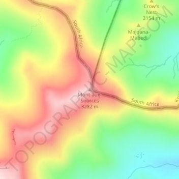
Name: Mont-aux-Sources topographic map, elevation, terrain.
Location: Mont-aux-Sources, Mokhotlong District, Lesotho (-28.77225 28.87305 -28.77215 28.87315)
Average elevation: 10,213 ft
Minimum elevation: 9,678 ft
Maximum elevation: 10,755 ft
Make a donation
Gear up for your next adventure:
As an Amazon Associate, this site earns from qualifying purchases at no extra cost to you.
Other topographic maps
Click on a map to view its topography, its elevation and its terrain.