
Walker Bay topographic map
Click on the map to display elevation.
About this map
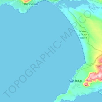
Name: Walker Bay topographic map, elevation, terrain.
Average elevation: 66 ft
Minimum elevation: -7 ft
Maximum elevation: 1,230 ft
Other topographic maps
Click on a map to view its topography, its elevation and its terrain.
Hermanus
South Africa > Western Cape > Overberg District Municipality > Overstrand Local Municipality
Average elevation: 285 ft
Stanford
South Africa > Western Cape > Overberg District Municipality > Overstrand Local Municipality
Average elevation: 351 ft
Onrus River
South Africa > Western Cape > Overberg District Municipality > Overstrand Local Municipality
Average elevation: 761 ft
Hawston
South Africa > Western Cape > Overberg District Municipality > Overstrand Local Municipality
Average elevation: 194 ft
Dyer Island
South Africa > Western Cape > Overberg District Municipality > Overstrand Local Municipality
Average elevation: 0 ft
Geyser Island
South Africa > Western Cape > Overberg District Municipality > Overstrand Local Municipality
Average elevation: 0 ft
Pringle Bay
South Africa > Western Cape > Overberg District Municipality > Overstrand Local Municipality
Average elevation: 203 ft
Mooiuitsig
South Africa > Western Cape > Overberg District Municipality > Overstrand Local Municipality
Average elevation: 568 ft