
Pringle Bay topographic map
Click on the map to display elevation.
About this map
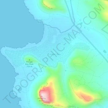
Name: Pringle Bay topographic map, elevation, terrain.
Average elevation: 203 ft
Minimum elevation: -3 ft
Maximum elevation: 1,430 ft
Other topographic maps
Click on a map to view its topography, its elevation and its terrain.
Pearly Beach
South Africa > Western Cape > Overberg District Municipality > Overstrand Local Municipality
Average elevation: 36 ft
Gansbaai
South Africa > Western Cape > Overberg District Municipality > Overstrand Local Municipality
Average elevation: 112 ft
Onrus River
South Africa > Western Cape > Overberg District Municipality > Overstrand Local Municipality
Average elevation: 761 ft
Baardskeerdersbos
South Africa > Western Cape > Overberg District Municipality > Overstrand Local Municipality
Average elevation: 394 ft
Kleinmond
South Africa > Western Cape > Overberg District Municipality > Overstrand Local Municipality
Average elevation: 390 ft
Walker Bay
South Africa > Western Cape > Overberg District Municipality > Overstrand Local Municipality
Average elevation: 66 ft
Dyer Island
South Africa > Western Cape > Overberg District Municipality > Overstrand Local Municipality
Average elevation: 0 ft
Geyser Island
South Africa > Western Cape > Overberg District Municipality > Overstrand Local Municipality
Average elevation: 0 ft
Pearly Beach
South Africa > Western Cape > Overberg District Municipality > Overstrand Local Municipality
Average elevation: 36 ft
Pearly Beach
South Africa > Western Cape > Overberg District Municipality > Overstrand Local Municipality
Average elevation: 36 ft
Walker Bay
South Africa > Western Cape > Overberg District Municipality > Overstrand Local Municipality
Average elevation: 66 ft
Onrusrivier
South Africa > Western Cape > Overberg District Municipality > Overstrand Local Municipality
Average elevation: 430 ft
Baardskeerdersbos
South Africa > Western Cape > Overberg District Municipality > Overstrand Local Municipality
Average elevation: 394 ft