
White Rock Lake topographic map
Interactive map
Click on the map to display elevation.
About this map
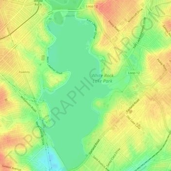
Name: White Rock Lake topographic map, elevation, terrain.
Location: White Rock Lake, Dallas, Dallas County, Texas, United States (32.81483 -96.73187 32.85513 -96.71188)
Average elevation: 499 ft
Minimum elevation: 420 ft
Maximum elevation: 564 ft
Other topographic maps
Click on a map to view its topography, its elevation and its terrain.
Stevens Park
United States > Texas > Dallas County > Dallas
Stevens Park, Dallas, Dallas County, Texas, United States
Average elevation: 558 ft
Lake Cliff Park
United States > Texas > Dallas County > Dallas
Lake Cliff Park, Dallas, Dallas County, Texas, United States
Average elevation: 469 ft
Reinhardt
United States > Texas > Dallas County > Dallas
Reinhardt, Dallas, Dallas County, Texas, 75218, United States
Average elevation: 538 ft
Flag Pole Hill Park
United States > Texas > Dallas County > Dallas
Flag Pole Hill Park, 8015, Dallas, Dallas County, Texas, 75201, United States
Average elevation: 515 ft
West End Square
United States > Texas > Dallas County > Dallas
West End Square, Downtown PID, Dallas, Dallas County, Texas, United States
Average elevation: 440 ft
Oak Cliff
United States > Texas > Dallas County > Dallas > Oak Cliff
Oak Cliff, Dallas, Dallas County, Texas, 75203, United States
Average elevation: 499 ft
Audelia
United States > Texas > Dallas County > Dallas
Audelia, Dallas, Dallas County, Texas, 75243, United States
Average elevation: 607 ft
Cole
United States > Texas > Dallas County > Dallas
Cole, Dallas, Dallas County, Texas, 75236, United States
Average elevation: 640 ft
Sargent
United States > Texas > Dallas County > Dallas
Sargent, Dallas, Dallas County, Texas, 75215, United States
Average elevation: 443 ft
Gifford
United States > Texas > Dallas County > Dallas
Gifford, Dallas, Dallas County, Texas, 75251, United States
Average elevation: 558 ft
Eagle Ford
United States > Texas > Dallas County > Dallas > Eagle Ford
Eagle Ford, Dallas, Dallas County, Texas, 75212, United States
Average elevation: 430 ft
Ledbetter Hills
United States > Texas > Dallas County > Dallas > Ledbetter Hills
Ledbetter Hills, Dallas, Dallas County, Texas, 75236, United States
Average elevation: 653 ft
Joppa Preserve
United States > Texas > Dallas County > Dallas
Joppa Preserve, Dallas, Dallas County, Texas, United States
Average elevation: 404 ft
Klyde Warren Park
United States > Texas > Dallas County > Dallas
Klyde Warren Park, Klyde Warren Park-Arts District PID, Dallas, Dallas County, Texas, 75201, United States
Average elevation: 466 ft
Inwood
United States > Texas > Dallas County > Dallas
Inwood, Dallas, Dallas County, Texas, 75244, United States
Average elevation: 617 ft
Rylie
United States > Texas > Dallas County > Dallas
Rylie, Dallas, Dallas County, Texas, 75253, United States
Average elevation: 449 ft