
Audelia topographic map
Click on the map to display elevation.
About this map
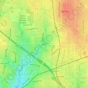
Name: Audelia topographic map, elevation, terrain.
Location: Audelia, Dallas, Dallas County, Texas, 75243, United States (32.88929 -96.73722 32.92929 -96.69722)
Average elevation: 607 ft
Minimum elevation: 512 ft
Maximum elevation: 676 ft
Dallas County trails, hiking, mountain biking, running and outdoor activities
Other topographic maps
Click on a map to view its topography, its elevation and its terrain.
Deep Ellum PID
United States > Texas > Dallas County > Dallas
Following World War II, the success of Deep Ellum started to fade. The ever-growing availability and use of the automobile led to the removal of the Houston and Texas Central railroad tracks—to make way for Central Expressway—and by 1956 the streetcar line had been removed. Businesses closed, residents…
Average elevation: 476 ft